
Quick answer
The Aral Sea is not completely gone, but it has shrunk to roughly ten percent of its former area. Small remnants persist in the North Aral Sea—stabilized by the Kok-Aral Dam in Kazakhstan—and intermittent shallow pools in the South Aral basin, which straddles Uzbekistan. The exposed seabed now stretches across thousands of square kilometers, marked by salt deposits, beached vessels, and wind-driven dust storms that carry pesticide residue across Central Asia.
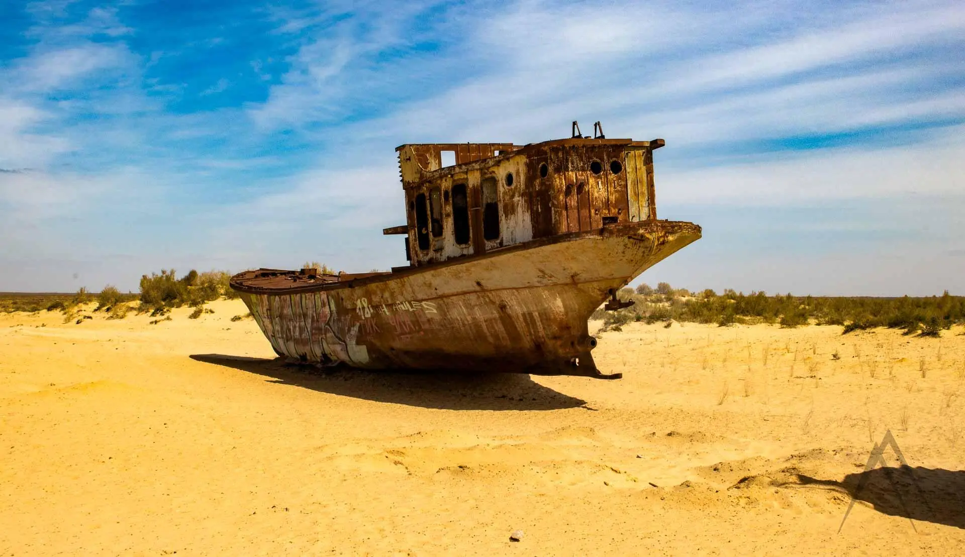
The ship graveyard at Moynaq sits more than one hundred kilometers from the nearest shoreline. That single fact captures the scale of retreat more vividly than any statistic. Hulls that once moored in a bustling fishing port now rest on sand and hardened salt, surrounded by saxaul scrub and the horizontal geometry of an evaporated lake. Is the Aral Sea gone? The answer hinges on definition. The body of water that Soviet irrigation diverted from the Amu Darya and Syr Darya rivers no longer functions as a single hydrological unit. The North Aral Sea—also called the Small Aral—holds a stable remnant behind a thirteen-kilometer dike completed in 2005. Water depth there averages eight meters, sufficient to support a modest fishery and draw migratory birds each spring. The South Aral basin, by contrast, exists as a fragmented patchwork: a western lobe that occasionally receives inflow from the Amu Darya during high-melt years, and an eastern basin that dried into mineral crust by the late 1990s. Satellite imagery from 2026 confirms intermittent water in the western lobe, though salinity exceeds ocean levels and biological activity remains negligible. The lakebed itself is now a destination. Travelers crossing the former seabed encounter a pale, mineral-dusted plain interrupted by low ridges of desiccated clay and the occasional vertebrae of a fish catch abandoned mid-journey. The exposed sediment contains decades of agricultural runoff—fertilizers, pesticides, defoliants—that wind redistributes across a radius of several hundred kilometers. Dust storms originating from the Aralkum Desert, the name now applied to the dry seabed, have been documented as far east as the Pamirs and as far north as the Russian steppe. Visitors who ask whether the Aral Sea has disappeared entirely are often surprised to learn that water persists, however diminished. The North Aral Sea recovery project demonstrates that intervention can stabilize a remnant basin when upstream flow is partially restored. The South Aral, lacking comparable infrastructure or political coordination between riparian states, continues to fluctuate with seasonal melt and evaporation. What remains is a geography of absence: shorelines marked by rusted infrastructure, former ports marooned inland, and a horizon unbroken by the reflective surface that once defined the region. The question is less whether the sea is gone than what its partial disappearance means for the communities and ecosystems that depended on it.
“The ship graveyard at Moynaq sits more than one hundred kilometers from the nearest shoreline.”
Is the Aral Sea Gone? Current Geography and State
The Aral Sea is not a single body of water, but a fragmented landscape undergoing significant environmental change. Its geography has been reshaped into distinct, isolated basins due to the diversion of its primary feeder rivers.
Two distinct basins
The sea is divided into the North Aral Sea in Kazakhstan and the South Aral Sea, which spans parts of Uzbekistan and Kazakhstan.
North Aral recovery
The Kokaral Dam, completed in 2005, successfully raised water levels in the North Aral, partially restoring local fisheries and ecosystems.
South Aral fragmentation
The South Aral Sea has separated into the deeper Western Basin and the shallower, hyper-saline Eastern Basin.
4th largest lake loss
Historically the world's fourth-largest lake, the Aral Sea lost more than 80 percent of its water volume since the 1960s.
Increasing salinity
As water levels receded, the concentration of salt and minerals increased, making the remaining water unsuitable for most native fish species.
Desert formation
The exposed lakebed is now known as the Aralkum Desert, covering thousands of square kilometers of former seafloor.
Historical Context: How Is the Aral Sea Gone?
The Aral Sea once ranked as the world's fourth-largest lake, fed by the Amu Darya and Syr Darya rivers flowing from the Pamir and Tian Shan mountains. For centuries it sustained fishing communities and moderated the climate of the surrounding steppe. By 1960, Soviet central planners launched an irrigation campaign to transform the deserts of Uzbekistan and Kazakhstan into cotton and rice fields. Engineers diverted both feeder rivers into an expanding network of canals, and the sea began to recede. Between 1960 and 1987, the Aral's surface area shrank by half. Salinity doubled, then tripled, killing endemic fish species and collapsing the commercial fleet based in Muynak and Aralsk. The southern basin separated from the northern lobe in 1987, and by 2000 the sea had fractured into distinct remnants. Dust storms carried salt and pesticide residue across the exposed seabed—now called the Aralkum Desert—depositing toxins hundreds of kilometers downwind. Is the Aral Sea gone? The North Aral, dammed in 2005 by the Kok-Aral Dyke, has stabilized and partially refilled; the South Aral continues to evaporate, leaving only a shallow western pool by 2014. Today the former seabed stretches more than 100 kilometers from Muynak's shore to the waterline. Rusted trawlers rest on hardpan where waves once lapped, and the harbor cranes stand isolated against the desert horizon. The North Aral supports a modest fishery again, but the vast southern basin remains a monument to irrigation policy and hydrological collapse, accessible to visitors willing to cross the Aralkum's salt flats.
The Aral Sea spans 68,000 square kilometers, supporting commercial fisheries in Muynak and Aralsk.
Soviet planners divert the Amu Darya and Syr Darya rivers to irrigate cotton and rice across Central Asia.
The sea splits into northern and southern basins as water levels fall below the connecting channel.
The southern basin fractures into eastern and western lobes; salinity exceeds ocean levels.
Kazakhstan completes the Kok-Aral Dyke, stabilizing the North Aral and allowing partial recovery.
The eastern lobe of the South Aral desiccates entirely, leaving only a shallow western remnant.
Directions for Visiting the Area Where Is the Aral Sea Gone
The Aral Sea is located in Central Asia, straddling the border of Kazakhstan and Uzbekistan. Accessing the region from Khiva requires traveling across remote desert terrain that necessitates the use of specialized 4x4 vehicles.
4x4 expedition via Nukus and Muynak
Private hire from Khiva to Muynak
Best Time to Witness the Landscape Where Is the Aral Sea Gone
The optimal period to visit the Aral Sea basin is during the spring months of April and May or autumn in September and October. These months provide stable conditions necessary for the demanding off-road navigation required to reach the receding shoreline.
Spring (April–May)
Minimal15°C to 25°C; mild temperatures.
Mild weather allows for easier navigation across the dry seabed.
Autumn (September–October)
Minimal10°C to 20°C; cooling trends.
The desert climate stabilizes, reducing the risk of extreme heat.
Daily Window (06:00–19:00)
None—
Daylight is essential for safety, as navigating remote, off-road terrain requires clear visibility.
Verdict: The best time to visit is April, May, September, or October, strictly adhering to the daily arrival window of 06:00–19:00.
Operational Hours for Exploring Where Is the Aral Sea Gone
The Aral Sea is a remote, open-access landscape that remains accessible at all times. Visitors may explore the region any day of the week.
| Monday | 00:00–23:59 | |
|---|---|---|
| Tuesday | 00:00–23:59 | |
| Wednesday | 00:00–23:59 | |
| Thursday | 00:00–23:59 | |
| Friday | 00:00–23:59 | |
| Saturday | 00:00–23:59 | |
| Sunday | 00:00–23:59 |
Check availability
Common questions about the Aral Sea's current status
Everything you need to know about is the aral sea gone